FAA Part 107 Pilot
Drone photography in The Villages and Central Florida.
The whole property, the whole neighborhood, one frame.
Around here the lifestyle is the listing. Golf course frontage, preserve views, the Harris Chain of Lakes, town square proximity. Insured aerial photography puts the things buyers actually move for into your gallery, legally and safely.
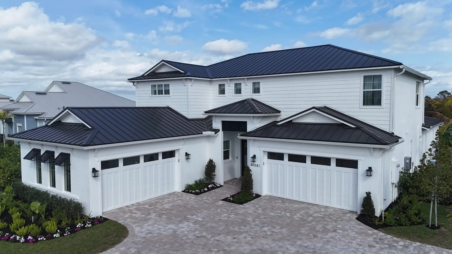
A certified pilot, insured, and legal to fly
Every FrameFocus flight is operated by an FAA Part 107 certified remote pilot carrying liability insurance. That matters more than most agents realize: uncertified drone photography on a paid shoot violates federal regulations and can expose you and your brokerage to liability. With us, airspace checks, authorizations and safe operation are handled before the drone ever leaves the case.
Aerial coverage includes high-resolution stills, optional 4K video orbits and flyovers, and edited deliverables with the same blue skies guarantee as our ground photography.
What aerial coverage shows that ground photos cannot
Lot lines and acreage. Distance to the gate, the golf course, the square. Roof and exterior condition. Water frontage and dock access. For golf course homes, equestrian property near Ocala, and lakefront listings on the Harris Chain, the aerial set is routinely the reason a buyer clicks through. Builders and developers also rely on our aerials for community progress documentation and model home marketing.
Aerials also answer the objection a ground gallery leaves open. A buyer looking at a Villages resale wants to know how far the home actually sits from the pool, the pickleball courts and the nearest gate. One elevated frame settles it, and the showing request that follows comes from someone who already knows the answer.
How an aerial session runs, and what the FAA rules mean for you
Before the drone comes out of the case we check the airspace. Much of Lake, Sumter and Marion county sits under controlled airspace shelves tied to Leesburg International, Ocala International and the smaller fields around them. Where an authorization is required we request it through LAANC, which is usually granted in seconds but occasionally needs a longer lead time. Booking a day or two ahead avoids the only scheduling problem aerials ever cause.
Flights are planned around light and wind. Front elevations photograph best with the sun behind the drone, so a west-facing home in The Villages shoots better in the afternoon and an east-facing one in the morning. Wind above roughly 20 miles per hour compromises stability, which is one of the reasons the free weather reschedule exists.
On site we fly a consistent set: a straight-on elevated front elevation, a rising reveal, two or three orbit angles, a top-down lot shot showing boundaries, and context frames pointing at whatever the property is selling, water, fairway, preserve or town square. Video packages add cinematic orbits and flyovers cut from the same session.
Why certification and insurance matter to the listing agent
Hiring an uncertified pilot for a paid shoot is a federal violation, and the exposure does not sit only with the pilot. Brokerages have policies about it for a reason, and a claim after an incident is a poor time to discover the operator was not covered.
Every FrameFocus flight is operated under a current FAA Part 107 remote pilot certificate with liability insurance in force. If your brokerage needs a certificate of insurance or wants the certificate number on file, ask and we will send it before the shoot.
Deliverables
What you receive.
Every item below is part of the standard package. Nothing here is an upsell discovered after the shoot.
- 01
High-resolution aerial stills
Elevated front elevation, orbit angles, top-down lot shot and context frames, all edited to match your ground gallery.
- 02
4K aerial video, optional
Cinematic orbits, rising reveals and flyovers, cut into your listing film or delivered as standalone clips.
- 03
Blue skies guarantee
Sky replacement applies to aerials exactly as it does to ground exteriors.
- 04
Airspace authorization handled
LAANC requests, controlled airspace checks and flight planning are done before we arrive. Nothing for you to file.
- 05
Certificate and insurance on request
Part 107 certificate number and proof of liability coverage available for your brokerage file.
- 06
Matched color and delivery
Aerials arrive in the same 24 hour window and the same gallery as your photography set.
Coverage
Where we shoot across Central Florida.
Aerial demand in this market clusters around exactly the things people move here for. Golf course frontage across The Villages, Stonecrest and Spruce Creek. Water on the Harris Chain in Leesburg and Lake Dora in Mount Dora. Acreage and pasture across Marion County horse country. New construction across Wildwood and the southern growth corridor.
We fly regularly in Lady Lake, The Villages, Leesburg, Wildwood, Fruitland Park, Mount Dora, Ocala and Summerfield, and we know which of those addresses tend to need an authorization before the flight. That local knowledge is why aerials rarely delay a listing when we shoot them.
Included
What comes standard.
Part 107 certified pilot
Legal commercial operation with full liability insurance.
Stills and 4K video
Orbits, flyovers, top-down lot shots and elevated front exteriors.
Lifestyle context
Golf, water, preserve and community amenities framed with the home.
Progress documentation
Recurring aerial documentation for builders and developers.
Questions
Drone and Aerial FAQs.
Something not answered here? Send a note through the contact page and we reply the same business day.
Do you need FAA certification to take drone photos of a listing?
Yes. Any drone flight for a commercial purpose, which includes marketing a property for sale, requires the pilot to hold a current FAA Part 107 remote pilot certificate. A hobbyist certificate does not cover it. Every FrameFocus flight is operated under Part 107 with liability insurance in force.
Can you fly a drone in The Villages and around Leesburg airport?
Yes, with the right authorization. Parts of Lake, Sumter and Marion county sit under controlled airspace tied to Leesburg International and Ocala International. Where an authorization is needed we request it through LAANC before the shoot, which is usually approved in seconds. Booking a day or two ahead means airspace never delays your listing.
What is included in an aerial photography add-on?
A set of high-resolution aerial stills covering the elevated front elevation, orbit angles, a top-down lot shot showing boundaries, and context frames pointing at the golf course, water or preserve the property backs onto. 4K aerial video is available alongside it.
Can you fly if it is windy?
Up to a point. Light wind is a non-issue, but sustained wind above roughly 20 miles per hour compromises stability and image quality, and we will not deliver a shaky aerial set to hit a date. If conditions are unsafe or unflattering we reschedule the aerial portion at no charge.
Do you shoot aerials for builders and developers, not just listings?
Regularly. Recurring aerial documentation of a site through each phase of construction is one of our most requested commercial services, and the same footage doubles as marketing media once the project sells. See our construction and development page for how those packages are structured.
Further Reading
More on Drone and Aerial from the blog.
Written for agents and owners weighing this against the alternatives, not for search engines.
Add drone and aerial coverage to your next shoot. Booked in minutes.
Book online in minutes with set prices and a live calendar, or call or text with any question. Most shoots are scheduled within the week.